चित्र:Klimagürtel-der-erde-warmgemäßigte-zone.png

इस पूर्वावलोकन का आकार: 800 × 400 पिक्सेल। दूसरे रेसोल्यूशन्स: 320 × 160 पिक्सेल | 640 × 320 पिक्सेल | 1,024 × 512 पिक्सेल | 1,280 × 640 पिक्सेल | 3,600 × 1,800 पिक्सेल।
मूल चित्र ((3,600 × 1,800 पिक्सेल, फ़ाइल का आकार: 713 KB, MIME प्रकार: image/png))
|
|
यह फ़ाइल विकिमेडिया कॉमन्स से है। वहाँ पर इसका विवरण पृष्ठ निम्नोक्त है। कॉमन्स मुक्त लाइसेंसों के अंतर्गत उपलब्ध मीडिया फ़ाइलों का संग्रह है। आप भी इसमें मदद कर सकते हैं। |
सारांश
| विवरण |
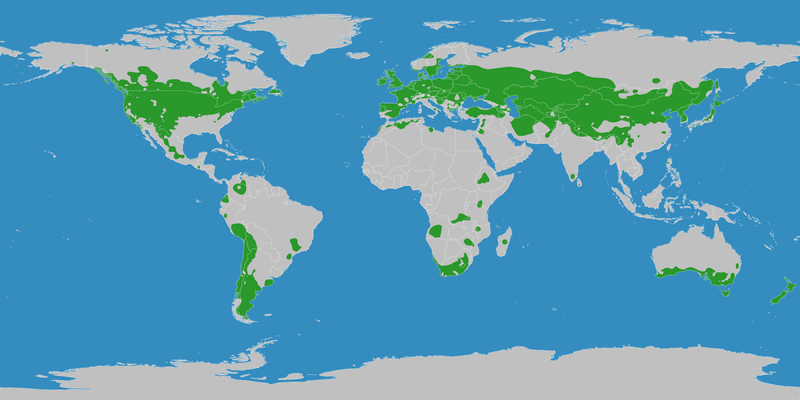
English: This map shows the Earth zones with a warm temperate climate. Deutsch: Diese Karte stellt die warmgemäßigte Klimazone der Erde dar. KORREKTUR: Es handelt sich hier um die kühlgemäßigten Klimate, siehe Artikel in der deutschen Wikipedia |
| दिनांक | |
| स्रोत |
English: Own work on the basis of the following data: Deutsch: Selbst erstellt auf Basis dieser Geodaten:
|
| लेखक | LordToran |
| अनुमति (इस चित्र का पुनः उपयोग करना) |
|
| दूसरे संस्करण |
 |
लाइसेंस
इस फ़ाइल को क्रिएटिव कॉमन्स श्रेय-समानसांझा 3.0 अनरिपोर्टेड लाइसेंस के अंतर्गत लाइसेंस किया गया है।
- आप खुलकर:
- बाँट सकते हैं – रचना की प्रतिलिपि बना सकते हैं, बाँँट सकते हैं और संचारित कर सकते हैं
- रीमिक्स कर सकते हैं – कार्य को अनुकूलित कर सकते हैं
- निम्नलिखित शर्तों के अंतर्गत:
- श्रेय – यह अनिवार्य है कि आप यथोचित श्रेय प्रदान करें, लाइसेंस की कड़ी प्रदान करें, और अगर कोई बदलाव हुए हों तो उन्हें इंगित करें। आप ऐसा किसी भी उचित तरीके से कर सकते हैं, लेकिन किसी भी तरह उससे यह नहीं संकेत नहीं किया जाना चाहिए कि लाइसेंसधारी द्वारा आपको अथवा आपके इस प्रयोग का समर्थन किया जा रहा हो।
- समानसांझा – अगर आप इस रचना में कोई बदलाव करते हैं या इसपर आधारित कुछ रचित करते हैं तो आप अपने योगदान को सिर्फ इसी या इसके सामान किसी लाइसेंस के अंतर्गत बाँट सकते हैं।
चित्र का इतिहास
फ़ाइलका पुराना अवतरण देखने के लिये दिनांक/समय पर क्लिक करें।
| दिनांक/समय | थंबनेल | आकार | सदस्य | प्रतिक्रिया | |
|---|---|---|---|---|---|
| वर्तमान | 21:10, 11 अक्टूबर 2016 | | 3,600 × 1,800 (713 KB) | Maphobbyist | The Caspian Sea was omitted. The Köppen system is based on the concept that climate types are correlated with the natural vegetation. |
| 15:30, 15 अक्टूबर 2007 |  | 3,600 × 1,800 (615 KB) | Lortordermur | ||
| 20:51, 5 जून 2007 |  | 3,445 × 1,731 (653 KB) | Lortordermur | == Beschreibung == {{Information |Description=Diese Karte stellt die warmgemäßigte Klimazone der Erde dar. |Source=Selbst erstellt auf Basis [http://www.copernicus.org/EGU/hess/hessd/4/439/hessd-4-439.htm dieser Karte], welche unter einer Creative-Comm |
चित्र का उपयोग
निम्नलिखित पन्ने इस चित्र से जुडते हैं :
चित्र का वैश्विक उपयोग
इस चित्र का उपयोग इन दूसरे विकियों में किया जाता है:
- ca.wiki.x.io पर उपयोग
- da.wiki.x.io पर उपयोग
- da.wikibooks.org पर उपयोग
- eu.wiki.x.io पर उपयोग
- he.wiki.x.io पर उपयोग
- pl.wiki.x.io पर उपयोग