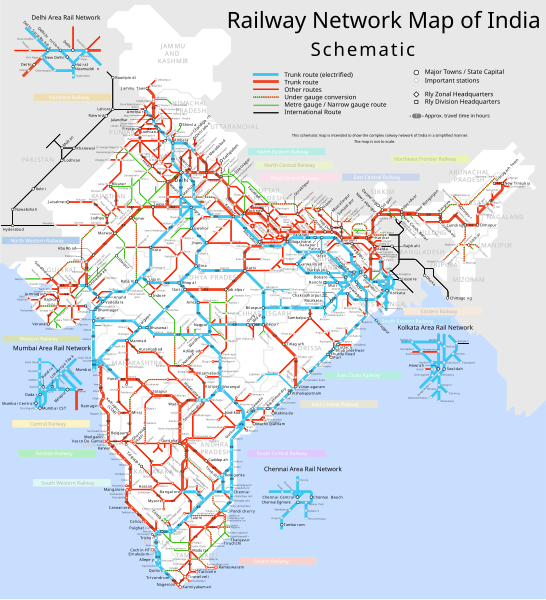
चित्र:Railway network map of India - Schematic.svg

पूर्वावलोकन PNG का आकार SVG फ़ाइल: 546 × 599 पिक्सेल दूसरे रेसोल्यूशन्स: 219 × 240 पिक्सेल | 437 × 480 पिक्सेल | 700 × 768 पिक्सेल | 933 × 1,024 पिक्सेल | 1,865 × 2,048 पिक्सेल | 879 × 965 पिक्सेल।
मूल चित्र (SVG फ़ाइल, साधारणतः 879 × 965 पिक्सेल, फ़ाइल का आकार: 865 KB)
चित्र का इतिहास
फ़ाइलका पुराना अवतरण देखने के लिये दिनांक/समय पर क्लिक करें।
| दिनांक/समय | थंबनेल | आकार | सदस्य | प्रतिक्रिया | |
|---|---|---|---|---|---|
| वर्तमान | 14:13, 3 अगस्त 2022 |  | 879 × 965 (865 KB) | Railmodel | fixed major text labels |
| 12:36, 13 सितंबर 2006 |  | 879 × 965 (930 KB) | Planemad | {{WikiProject_India_Maps |Title=India railway schematic |Description=Schematic map of the entire Indian railway network |Source=. |Date=Sepetember 2006 |Author=w:user:Planemad |Thumbdir=CHANGE }} |
चित्र का उपयोग
निम्नलिखित पन्ने इस चित्र से जुडते हैं :
चित्र का वैश्विक उपयोग
इस चित्र का उपयोग इन दूसरे विकियों में किया जाता है:
- ar.wiki.x.io पर उपयोग
- as.wiki.x.io पर उपयोग
- bn.wiki.x.io पर उपयोग
- ce.wiki.x.io पर उपयोग
- cs.wiki.x.io पर उपयोग
- de.wiki.x.io पर उपयोग
- de.wikivoyage.org पर उपयोग
- en.wiki.x.io पर उपयोग
- Portal:India/Today's selected article/October 2006
- Portal:India/Today's selected article/October 12, 2006
- Portal:India/Selected picture candidates/Archived nominations
- Portal:India/SC Summary/SA Rail transport in India
- Portal:India/Selected picture candidates/India railway schematic map
- Portal:India/Today's selected article/January 2007
- Portal:India/Today's selected article/January 5, 2007
- Portal:India/Selected articles/Archive
- eo.wiki.x.io पर उपयोग
- es.wiki.x.io पर उपयोग
- fi.wiki.x.io पर उपयोग
- fr.wiki.x.io पर उपयोग
- fr.wikivoyage.org पर उपयोग
- gu.wiki.x.io पर उपयोग
- he.wiki.x.io पर उपयोग
- he.wikivoyage.org पर उपयोग
- hu.wiki.x.io पर उपयोग
- id.wiki.x.io पर उपयोग
- it.wiki.x.io पर उपयोग
- ja.wiki.x.io पर उपयोग
- kn.wiki.x.io पर उपयोग
- ml.wiki.x.io पर उपयोग
- mr.wiki.x.io पर उपयोग
- new.wiki.x.io पर उपयोग
- nl.wiki.x.io पर उपयोग
इस चित्र के वैश्विक उपयोग की अधिक जानकारी देखें।