चित्र:Constituencies Iceland.png
इससे बड़ा रेसोल्यूशन उपलब्ध नहीं हैं।
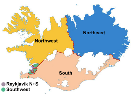
Constituencies_Iceland.png ((457 × 336 पिक्सेल, फ़ाइल का आकार: 136 KB, MIME प्रकार: image/png))
|
|
यह फ़ाइल विकिमेडिया कॉमन्स से है। वहाँ पर इसका विवरण पृष्ठ निम्नोक्त है। कॉमन्स मुक्त लाइसेंसों के अंतर्गत उपलब्ध मीडिया फ़ाइलों का संग्रह है। आप भी इसमें मदद कर सकते हैं। |
सारांश
| विवरण | The map is based on one from the website of the Land Survey of Iceland where it is stated that it may be used for any purposes without a special permission. |
| स्रोत | http://www.lmi.is/landmaelingar.nsf/pages/vefkort.html |
| लेखक | http://www.lmi.is/landmaelingar.nsf/pages/vefkort.html |
| दूसरे संस्करण |
Derivative works of this file: |
लाइसेंस
| यह चित्र कॉपीराइट के लिए अयोग्य है और इसलिए सार्वजनिक डोमेन में है क्योंकि इसमें सिर्फ ऐसी जानकारी है जो साधारण संपत्ति है और यह मौलिक रचना से मुक्त है। |
चित्र का इतिहास
फ़ाइलका पुराना अवतरण देखने के लिये दिनांक/समय पर क्लिक करें।
| दिनांक/समय | थंबनेल | आकार | सदस्य | प्रतिक्रिया | |
|---|---|---|---|---|---|
| वर्तमान | 22:20, 18 जुलाई 2009 | | 457 × 336 (136 KB) | Vearthy | {{Information |Description=The map is based on one from the website of the Land Survey of Iceland where it is stated that it may be used for any purposes without a special permission. |Source= http://www.lmi.is/landmaelingar.nsf/pages/vefkort.html |Date= |
चित्र का उपयोग
निम्नलिखित पन्ने इस चित्र से जुडते हैं :
चित्र का वैश्विक उपयोग
इस चित्र का उपयोग इन दूसरे विकियों में किया जाता है:
- ar.wiki.x.io पर उपयोग
- azb.wiki.x.io पर उपयोग
- ca.wiki.x.io पर उपयोग
- da.wiki.x.io पर उपयोग
- el.wiki.x.io पर उपयोग
- es.wiki.x.io पर उपयोग
- fi.wiki.x.io पर उपयोग
- fr.wiki.x.io पर उपयोग
- gl.wiki.x.io पर उपयोग
- ja.wiki.x.io पर उपयोग
- ka.wiki.x.io पर उपयोग
- ko.wiki.x.io पर उपयोग
- mk.wiki.x.io पर उपयोग
- pt.wiki.x.io पर उपयोग
- ro.wiki.x.io पर उपयोग
- ru.wiki.x.io पर उपयोग
- sco.wiki.x.io पर उपयोग
- sh.wiki.x.io पर उपयोग
- sl.wiki.x.io पर उपयोग
- sq.wiki.x.io पर उपयोग
- sr.wiki.x.io पर उपयोग
- uk.wiki.x.io पर उपयोग
- vi.wiki.x.io पर उपयोग
इस चित्र के वैश्विक उपयोग की अधिक जानकारी देखें।