मूल चित्र ((1,195 × 1,151 पिक्सेल, फ़ाइल का आकार: 409 KB, MIME प्रकार: image/jpeg))

This map image could be re-created using vector graphics as an SVG file. This has several advantages; see Commons:Media for cleanup for more information. If an SVG form of this image is available, please upload it and afterwards replace this template with {{vector version available|new image name}}.


It is recommended to name the SVG file “BD Map Rivers of North Bengal2.svg”—then the template Vector version available (or Vva) does not need the new image name parameter.
विवरण

Own map based on the Rivers of Bangladesh, August 1997 edition, produced by Graphosman, 55/1 Purana Paltan, Dhaka – 1000, map of Bengal in History of Ancient Bengal, by Dr. R.C. Majumdar,First published 1971, Reprint 2005, p. 4, Tulshi Prakashani, 9/7b Ramanath Mazumdar Street, Kolkata, ISBN 81-89118-01-3, map of Paschim Banger Nad-Nadi on p. 64 in Bharater Nadi (Rivers of India), 2002, by Dilip Kumar Bandopadhyay, বাংলা, Bharati Book Stall, 6B Ramanath Mazumdar Street, Kolkata.

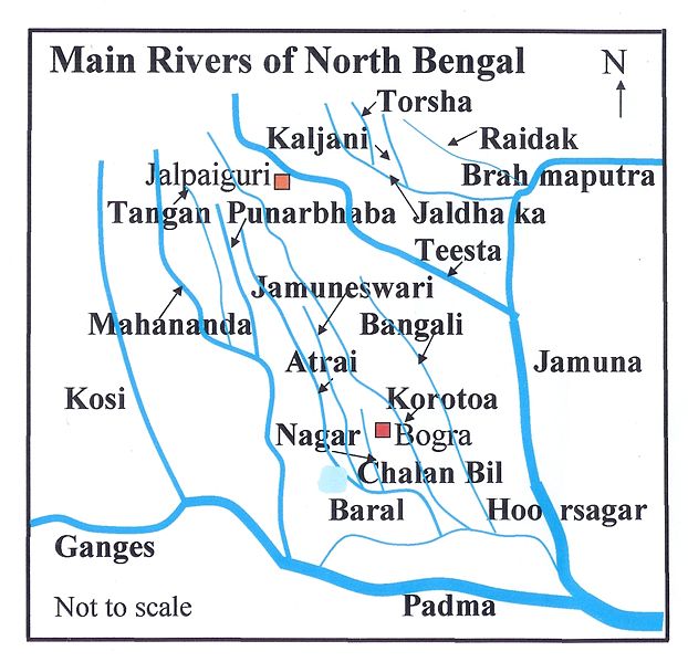
The map shows the main rivers in North Bengal and adjoining areas. However, there are numerous tributaries and distributaries, which connect the main rivers, and allow the main rivers to change course. Therefore, the river-system pattern undergoes continuous changes. Such changes have not been reflected in the map. Moreover, many of the rivers have local names for sections of the course, adding to the complexity of the river system. The map should be considered a broad overview and for more accurate presentation one has to refer to more detailed maps, as the one produced by Graphosman.
स्रोत http://en.wiki.x.io/wiki/Image:BD_Map_Rivers_of_North_Bengal.jpg
लेखक P.K.Niyogi
अनुमति
(इस चित्र का पुनः उपयोग करना)
मैं, इस कार्य का/की कॉपीराइट धारक, इसे निम्न लाइसेंस के अंतर्गत प्रकाशित करता/करती हूँ:
GNU head इस दस्तावेज़ को Free Software Foundation द्वारा प्रकाशित GNU मुक्त प्रलेख लाइसेंस के संस्करण 1.2 या नए (बिना किसी अपरिवर्तनीय अनुभागों और अगले या पिछले आवरण के टेक्स्ट के) के अंतर्गत प्रतिलिपि बनाने, बाँटने और/या बदलने की अनुमति प्रदान की जाती है। इस लाइसेंस की एक प्रतिलिपि GNU मुक्त प्रलेख लाइसेंस नामक अनुभाग में शामिल है।
w:hi:क्रिएटिव कॉमन्स
श्रेय समानसांझा
इस फ़ाइल को क्रिएटिव कॉमन्स श्रेय-समानसांझा 3.0 अनरिपोर्टेड लाइसेंस के अंतर्गत लाइसेंस किया गया है।
आप खुलकर:
  • बाँट सकते हैं – रचना की प्रतिलिपि बना सकते हैं, बाँँट सकते हैं और संचारित कर सकते हैं
  • रीमिक्स कर सकते हैं – कार्य को अनुकूलित कर सकते हैं
निम्नलिखित शर्तों के अंतर्गत:
  • श्रेय – यह अनिवार्य है कि आप यथोचित श्रेय प्रदान करें, लाइसेंस की कड़ी प्रदान करें, और अगर कोई बदलाव हुए हों तो उन्हें इंगित करें। आप ऐसा किसी भी उचित तरीके से कर सकते हैं, लेकिन किसी भी तरह उससे यह नहीं संकेत नहीं किया जाना चाहिए कि लाइसेंसधारी द्वारा आपको अथवा आपके इस प्रयोग का समर्थन किया जा रहा हो।
  • समानसांझा – अगर आप इस रचना में कोई बदलाव करते हैं या इसपर आधारित कुछ रचित करते हैं तो आप अपने योगदान को सिर्फ इसी या इसके सामान किसी लाइसेंस के अंतर्गत बाँट सकते हैं।
This licensing tag was added to this file as part of the GFDL licensing update.

Captions

Add a one-line explanation of what this file represents

Items portrayed in this file

चित्रण

media type अंग्रेज़ी

image/jpeg

checksum अंग्रेज़ी

5a8d1b16fc25575ad9e771a37da467b26ca09474

data size अंग्रेज़ी

४,१९,२८८ बाइट

१,१५१ पिक्सल

width अंग्रेज़ी

१,१९५ पिक्सल

चित्र का इतिहास

फ़ाइलका पुराना अवतरण देखने के लिये दिनांक/समय पर क्लिक करें।

दिनांक/समयथंबनेलआकारसदस्यप्रतिक्रिया
वर्तमान06:26, 24 नवम्बर 200706:26, 24 नवम्बर 2007 के संस्करण का थंबनेल संस्करण1,195 × 1,151 (409 KB)Tarif{{Information |Description=Own map based on the ''Rivers of Bangladesh'', August 1997 edition, produced by Graphosman, 55/1 Purana Paltan, Dhaka – 1000, map of ''Bengal'' in ''History of Ancient Bengal'', by Dr. R.C. Majumdar,First published 1971, Repri

निम्नलिखित पन्ने इस चित्र से जुडते हैं :

चित्र का वैश्विक उपयोग

इस चित्र का उपयोग इन दूसरे विकियों में किया जाता है:

इस चित्र के वैश्विक उपयोग की अधिक जानकारी देखें।

मेटाडेटा